
After more than a year of planning, the Innovation Center successfully deployed a wind and wave data buoy (a Sofar Spotter) in Richardson Bay, a protected eel grass preserve between Sausalito and Tiburon in San Francisco. The project is part of an ongoing partnership between the Innovation Center, Professor Jason Pittman/FLC’s Geosciences Department, and the UC Davis Coastal and Marine Sciences Institute.

David Dann (UC Davis Marine Operations Manager) was one of two scuba divers who assisted with the mooring, and did the heavy lifting of the deployment. David expertly navigated the complex regulatory environment of California’s coastal waters, which included securing permits and coordinating with the Richardson Bay Audubon Center, San Francisco Bay Conservation and Development Commission, San Francisco Bay Regional Water Quality Control Board, the U.S. Army Corps of Engineers, the U.S. Coast Guard, the City of Belvedere, and Clipper Yacht harbor.

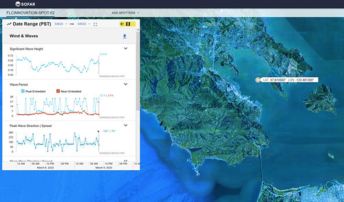
The data gathering buoy (which includes the Open Acoustic Devices HydroMoth audio recorder) is part of the Innovation Center’s larger “Quantified College” project, an effort to gather a variety of environmental data and to provide students with opportunities to use those data in a variety of ways, from sonification (i.e. creating music from data) to “big data” analysis as part of FLC’s innovative Artificial Intelligence curriculum. Data from the buoy will also be used to support coastal erosion research being conducted by UCD researchers. The project is the first of many for the partnership, with the overarching goal of providing FLC students with opportunities for hands-on field experiences, as well as transfer and career pathways. Have a look at the data!