Jason Pittman (Geosciences), Max Mahoney (Chemistry) and I took the new quadcopter out to Lava Cap Winery to do a test flight.

Flying

Dronedeploy (the system we use for flight planning and analysis) offers some interesting post-flight map creation and analysis. Here are the Plant Health and Elevation views.

Plant Health and Elevation

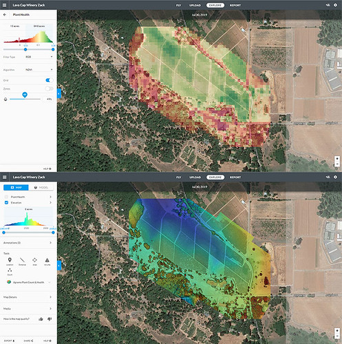
We were stoked to see the Model view for the first time.
Model

We’re still figuring out what it all means, but we’re excited about the preliminary results!

Got our new DJI Inspire 2 up in the air for the first time today!

2019-06-14_05-05-36

Using DroneDeploy for mission planning is surprisingly easy, and the quad is easy to control, with auto takeoff and auto landing.

The technology has come a long way since we built and flew our first quad back in 2012. We plan to use this one to continue to support remote sensing in the Geosciences, and to fly vineyards as part of our FermSci and viticulture efforts.

FLC's Garden From Above

Field day with Jason Pittman’s (Geosciences) mapping class yesterday. We flew the 3D printed picavet for the first time. After we worked the wetlands, two student volunteers agreed to walk the balloon up into campus, as I wanted to get shots of the garden. That little patch of green in the dry area (above) is the garden. Image below from a different flight for comparison.

FLC's Garden as Seen from Above

The entire dataset can be found at the project blog (DoLookDown.org), as well as the images from our 2014 and 2015 flights of the same area.  When I find the time, I plan to redesign and 3D print the picavet from the ground up, shaving some additional weight.

I got the blog up and running for a new project that Jason Pittman (Geosciences) and I are working on.

http://dolookdown.org and @DoLookDown on Twitter

The project will help FLC students develop technical geospatial analysis skills and learn contemporary applications of geospatial imaging, and the images will be used for spatial analysis; evaluating landscape changes, hazard analyses, and investigating rural and urban development.